Services

Volume calculation

Volume Calculations

Accurate volume measurements for planning, control, and documentation

Precise volume calculations are essential for efficient planning, cost control, and documentation in construction, infrastructure, and earthworks projects. Using drone-based LiDAR and photogrammetry, large and complex areas can be measured quickly and accurately with complete surface coverage.

FROST delivers reliable volume calculations based on high-resolution spatial datasets — supporting better decisions throughout the project lifecycle.

Why drone-based volume calculations?
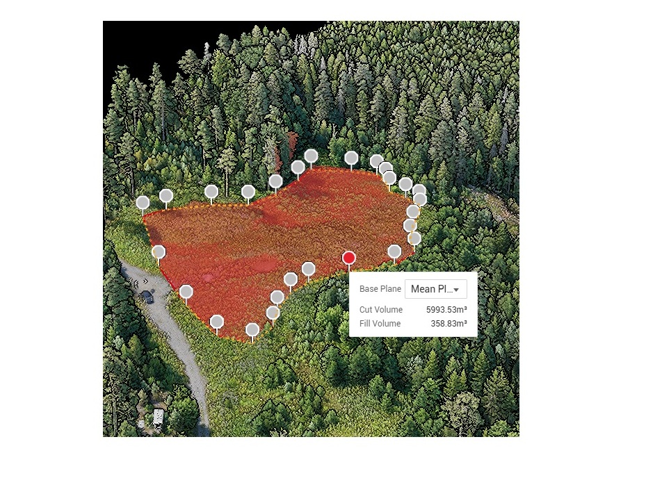
Traditional measurement methods can be time-consuming and limited in coverage. Drone-based workflows provide accurate and consistent surface data across the entire site.
Key advantages include:
  • Rapid data capture with minimal site disruption
  • High accuracy across large and complex environments
  • Full surface coverage instead of sampled measurements
  • Repeatable surveys for progress tracking and reporting

This creates a reliable basis for operational, technical, and financial decision-making.

Applications
Typical applications include:
  • Earthworks and mass balance calculations
  • Stockpile measurements for soil, gravel, and aggregates
  • Excavation and fill volume analysis
  • Construction progress tracking
  • As-built documentation
  • Quarry and mining operations
  • Waste and landfill monitoring
Data acquisition and workflow
FROST uses drone-based LiDAR and photogrammetry to generate detailed terrain and surface datasets.
Our workflow includes:
  • High-resolution data capture of the project area
  • Accurate georeferencing using GNSS and ground control
  • Generation of terrain and surface models (DTM / DSM)
  • Volume calculations based on reference surfaces or design models
Volumes can be calculated against:
  • Previous surveys and temporal datasets
  • Design models
  • Existing terrain or reference surfaces
Accuracy, monitoring, and progress tracking
Reliable volume calculations depend on both accurate data capture and consistent processing workflows.
FROST ensures:
  • High-resolution and consistent surface models
  • Accurate boundary and surface definitions
  • Reliable comparison between datasets
  • Transparent and repeatable calculation methods
Repeat surveys also enable continuous monitoring of site development, including:
  • Tracking excavation and fill progress
  • Documentation for billing and reporting
  • Detection of deviations from design
  • Improved control of timelines and project costs
Deliverables
We provide structured, analysis-ready outputs adapted to project and reporting requirements, including:
  • Volume calculation reports
  • Cut & fill analyses
  • Terrain and surface models (DTM / DSM)
  • Comparison datasets
  • GIS- and CAD-ready deliverables
Topographical LiDAR
Bathymetric LiDAR
Powerline inspection

Geospatial solutions powered by software, sensors, and AI technologies

Join us and help capture and transform accurate geospatial data into valuable insights and digital twins.

Join us
Volume Calculations

Volume calculation

Accurate volume measurements for planning, control, and documentation

Precise volume calculations are essential for efficient planning, cost control, and documentation in construction, infrastructure, and earthworks projects. Using drone-based LiDAR and photogrammetry, large and complex areas can be measured quickly and accurately with complete surface coverage.

FROST delivers reliable volume calculations based on high-resolution spatial datasets — supporting better decisions throughout the project lifecycle.